
Maritime Dominance in Real Time: What Hormuz Demands of U.S. Defense Technology


Published
Categories
Contributors
On February 28, 2026, coordinated U.S.-Israeli strikes on Iran triggered one of the most consequential maritime disruptions in modern history. Nearly seven weeks later, the Strait remains effectively closed. A ceasefire collapsed, a U.S. naval blockade is now in place, mine clearance operations are underway, and as of this writing, Iranian gunboats are firing on vessels attempting to transit. While every crisis has its unique characteristics, the Hormuz crisis has exposed structural gaps in US maritime capabilities that will outlast this conflict.
At the center of these gaps is the deterioration of U.S. mine countermeasures capability, which has been documented in public forums since at least 1991, argued in Congressional testimony, and dissected in the pages of Proceedings. The Mine Warfare Command was dissolved in 2006. What is new about the Hormuz conflict is that the audience has changed: every adversary planning the next contested chokepoint — including those watching from Beijing and taking notes on what mine warfare does to U.S. response timelines — now has a detailed, real-world demonstration of exactly where U.S. maritime capability breaks down.
Five Gaps That Technology Can Address Now
The Hormuz crisis has highlighted weaknesses in force posture, alliance coordination, energy dependence, and diplomatic preparation that technology alone cannot solve. Better war-gaming and scenario planning might have surfaced the need to position MCM assets in theater earlier, while sustained alliance diplomacy might have improved the odds of securing coalition contributions. The global energy system also remains heavily exposed to disruption in the Strait of Hormuz, one of the world’s most critical oil and LNG chokepoints. These are ultimately not problems of capability development, but of strategy and policy.
But five operational gaps at the core of the crisis are different. They are structural deficits in sensing, awareness, and autonomous response capability — and commercially proven, defense-ready technology exists to close them now.
AIS and GNSS degradation severely degraded the common operating picture for AIS-reliant monitoring. Over 600 GNSS disruption events were recorded across the operational area in a single 24-hour period on March 10, according to the Joint Maritime Information Center. AIS data in and around the Strait has been underreporting actual vessel traffic by an estimated 50%, due to ships going dark on transponders, spoofing GPS coordinates, and broadcasting false identities. On a single day in early April, 267 AIS-dark events were recorded across the Gulf region. Maritime intelligence firms have consistently found that AIS-dependent systems cannot independently verify the picture — and that multiple, independent sensing layers are required to establish ground truth.
Mine countermeasures capacity has atrophied to a critical low. The last four Avenger-class MCM ships in the Middle East — USS Devastator, Dextrous, Gladiator, and Sentry — were decommissioned in Bahrain in September 2025 and arrived in Philadelphia for scrapping just days before reports surfaced of Iranian minelaying in the Strait. Their replacement, three Independence-class Littoral Combat Ships (LCS) fitted with the MCM package, represent the entirety of the U.S. Navy’s dedicated MCM presence in the Fifth Fleet area of operations — and two of those ships were in Malaysia when the crisis began. The Pentagon’s own director of Operational Test and Evaluation reported that in FY2025, the Navy conducted no operational testing of the LCS MCM mission package and could not determine its operational effectiveness due to insufficient performance data.
Surface forces cannot safely operate inside the threat ring. Crewed mine clearance and escort missions face immediate and meaningful risk from missiles, drones, and fast craft. The density of the threat environment around the Strait makes manned operations in the immediate area costly and slow — the exact conditions under which mine clearance becomes a strategic paralytic rather than a tactical problem.
The water column is effectively dark. The Strait of Hormuz is one of the world’s most acoustically complex environments. Without persistent real-time data on temperature, salinity, current profiles, and sound velocity, commanders cannot optimize sonar performance, predict mine drift, or plan safe subsurface routing. This is not a new gap — it is a chronic one that the crisis has made operationally consequential.
Strategic logistics are a force vulnerability. Energy disruption quickly becomes a military logistics problem. Before the war, roughly 138 ships transited the Strait each day; since early March, fewer than 100 vessels have made the crossing in total. Brent crude rose nearly 60 percent in the first month of the closure. Autonomous systems operating in theater require persistent power that is independent of fuel supply chains — and many current platforms lack that independence.
For decades, maritime capability development has been defined by long procurement cycles, escalating costs, and increasingly exquisite platform requirements. Major naval systems now take years — often decades — to design, test, and field, with each iteration incorporating more advanced but also more complex and expensive technologies. This model has produced highly capable platforms, but at the cost of speed, scalability, and adaptability in the face of rapidly evolving threats.
The pace of modern maritime warfare has outrun the development and procurement timelines of legacy platforms. The answer cannot be to wait for the next generation of purpose-built programs.
A Capability Stack, Not a Collection of Products
The defense market is accustomed to evaluating platforms in isolation — a sensor, a vehicle, a power system — and then managing the integration problem separately. What the Hormuz crisis makes clear is that the gaps it exposed do not map to individual platforms. They map to a sequence: detect what is happening, plan a response with accurate environmental data, map the threat area without putting crews at risk, act autonomously to neutralize that threat, and sustain those operations independent of vulnerable fuel and supply chains. Each step in that sequence depends on the one before it. A mine neutralization asset operating without subsurface environmental data is less effective. An autonomous platform that cannot be powered independently becomes a logistics liability in exactly the scenario where logistics are already strained. We believe that the capabilities S2G’s portfolio represents are not six companies; they are one integrated answer to a sequenced operational problem.

The first requirement in any contested maritime environment is an independent, manipulation-proof picture of what is actually happening on the water. Unseenlabs addresses this at the detection layer. Its constellation — the world’s only mono-satellite RF collection architecture, with 20 satellites on orbit delivering 2 – 3 hour revisit rates — detects, geolocates, and characterizes vessels via their radio frequency emissions, entirely independent of AIS or GNSS. Where AIS has been spoofed or jammed, where transponders have been switched off, and where commercial SAR imagery is degraded by environmental conditions, RF sensing from orbit provides the only reliable source of ground truth. The architecture is ITAR-free, operates through a U.S. entity headquartered in Raleigh, North Carolina, and is designed for direct integration into existing maritime domain awareness systems.
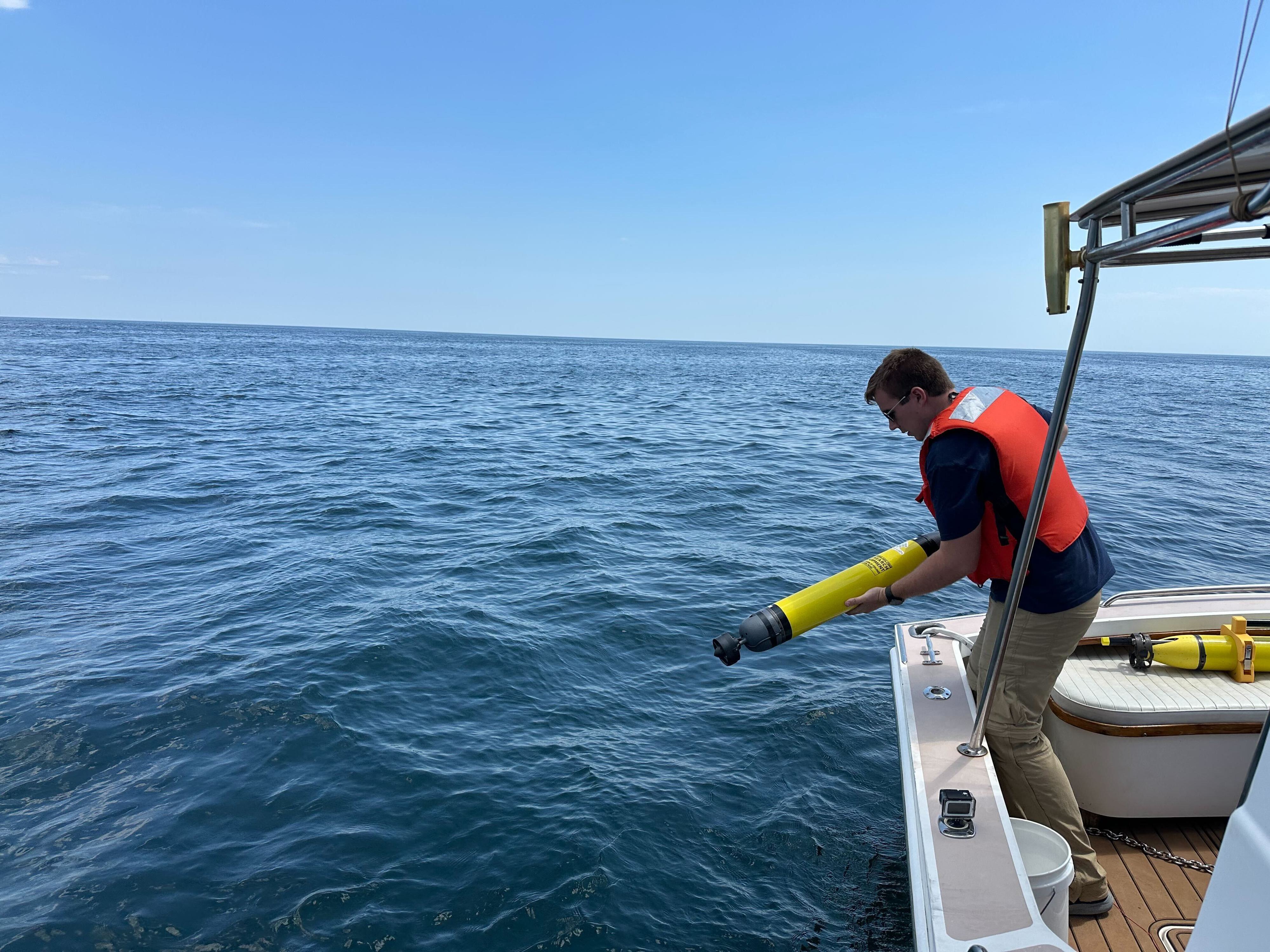
Knowing where vessels are is necessary but not sufficient. Commanders also need to know what the ocean itself is doing — the subsurface environmental conditions that determine sonar performance, mine drift trajectories, and safe routing. Two companies in the portfolio address this planning layer from complementary positions. Apeiron Labs, founded by Ravi Pappu, former CTO of In-Q-Tel, deploys low-cost AUVs that profile the upper 400 meters of the water column for temperature, salinity, and acoustic data at a fraction of traditional costs. The station-keeping network of vehicles are sized for U.S. Navy launch equipment and can be deployed from aircraft, requiring no surface support vessel in the threat area. Apeiron has already secured multiple contracts with U.S. government agencies.
Sofar Ocean complements this with the world’s largest private ocean sensor network — ruggedized, long-dwell buoys and surface sensors deployable from vessels or aircraft that deliver real-time marine weather and subsurface intelligence. Its proprietary forecasting models are more than 40% more accurate than traditional alternatives, and its optimized routing engine gives naval commanders the environmental picture required to make informed go/no-go decisions at speed.
With the operating picture established and the environment understood, the next requirement is to systematically map the physical threat area — seabed characterization, mine hunting, and infrastructure assessment — without putting sailors at risk.
XOCEAN operates the world’s largest fleet of survey-class uncrewed surface vehicles, collecting sonar, magnetometer, and environmental data continuously without crew, without fuel resupply dependency, and without reliance on satellite navigation for basic operations. XOCEAN’s USVs can be deployed at operational scale in the exact environments — contested, threat-dense, electronically degraded — where crewed survey vessels cannot safely operate, and data is delivered in formats directly accessible to allied navies. As the Strait eventually reopens, a full rescoping of transit lanes and unexploded ordnance will be required. We believe XOCEAN is built precisely for that mission.

Detection, planning, and mapping inform the action layer — and the action layer is where the MCM gap is most acute. Ocean Aero’s Triton is the world’s only Autonomous Underwater and Surface Vessel: wind and solar powered, capable of operating on the surface for 30 or more days or submerging to 328 feet for over 10 days to avoid detection. It is not a prototype. Triton has operated with Task Force 59 in the Persian Gulf and was deployed for continuous autonomous subsea surveillance at the Port of Gulfport — home to the Naval Construction Battalion Center — beginning in May 2025. Its mine detection payload is operational today: bathymetry, side-scan sonar, magnetometer, and high-resolution imaging. A mine neutralization capability using onboard effectors and wireless detonation is in the final stages of testing. In public statements, U.S. Navy officials have used the term ‘attritable’ to describe systems with certain cost and risk characteristics for operations in contested environments. The Triton is designed with similar objectives in mind.
Every platform in this stack — uncrewed surface vessels, autonomous underwater vehicles, persistent sensor arrays — requires power that is reliable, fast-charging, and independent of the fuel supply chains that become strategic vulnerabilities in a contested environment. Echandia provides this through maritime battery systems built on Lithium Titanate Oxide chemistry. Echandia’s LTO batteries deliver 20,000 – 30,000+ charge cycles with minimal degradation, a 15 – 20 year service life, and sustained high-rate pulse power for directed energy, radar, electronic warfare, and silent-running propulsion loads with inherent resistance to thermal runaway, shock, vibration, and extreme temperatures (−22°F to 131°F). Critically, LTO requires no graphite anodes, eliminating dependence on Chinese-controlled supply chains — a geopolitical resilience advantage that aligns directly with FY26 NDAA Section 842. Echandia systems are currently operational across commercial ferries, tugboats, and European naval frigates, with U.S. module assembly and full system manufacturing in Washington State.
This is not six companies solving six problems. We view these companies as one connected capability stack — from the first tip that something is wrong to the sustained autonomous operations required to address it.
What the Defense Community Should Take From This
We want to address a question that any serious defense operator or prime contractor will reasonably ask: why should commercially-developed, venture-backed technology be trusted with operational missions that legacy programs have failed to deliver?
The answer is not that commercial technology is inherently superior, although it can be. It is that the institutional failure modes that created the MCM gap are precisely the failure modes that commercial development cycles avoid. These companies were built to work in the real world first. Their defense relevance emerged from that requirement, not from a program of record.
The integration pathway for each runs through the existing defense industrial base, not around it. RF intelligence feeds directly into existing maritime domain awareness architectures. Apeiron’s AUVs are sized for Navy launch equipment by design. Triton has already operated alongside Task Force 59 assets and carries the attritable designation DoW has sought in its distributed maritime operations doctrine. XOCEAN delivers data in formats directly accessible to allied navies without classified infrastructure. Echandia holds ABS, DNV, Lloyd’s, and U.S. manufacturing credentials that meet defense procurement standards.
The Hormuz crisis has made the strategic case for this transition more legible than any white paper could. Iran demonstrated that a determined adversary can close a critical global waterway using mines, drones, and electronic warfare — cheap, scalable tools against which legacy platforms have no ready answer. The gap between what adversaries can do and what the U.S. Navy can respond with in real time is not a funding problem. It is a readiness and technology problem.
The next maritime crisis is not a question of if. Technology to respond to it exists today. The question is whether it will be in the theater when needed.


